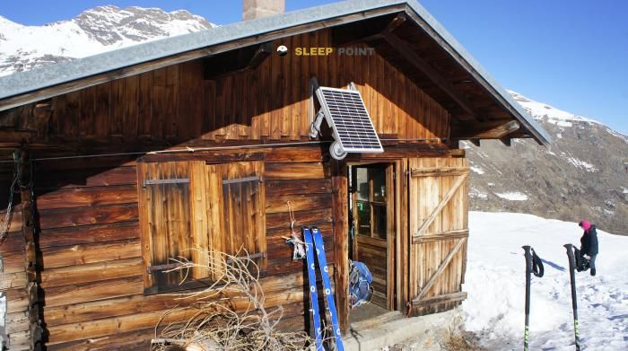
Mountain refuge Cabane des Ayes
We have it listed in the app!
We have it listed in the app!


Conquering the trails of l'argentière-la-bessée, briançon, altos alpes, provenza-alpes-costa azul, francia metropolitana, 05120, francia is easier with the Cabane des Ayes refuge. Located at 2269 m (coordinates 44.789, 6.438), it is the ideal shelter against harsh mountain weather.
7.1°C
Feels like: 4.2°C2.5 km/h
Gusts: 11.5 km/h4160 m
Snow lineUV 0
Clouds: 97% 31.1 mm
 15.1 km/h
 UV máx: 6
 05:50
05:50
 21:15
0.8 mm
11.5 km/h
UV máx: 8
05:49
21:15
0 mm
13.1 km/h
UV máx: 7
05:49
21:16
0 mm
10.7 km/h
UV máx: 8.15
05:49
21:17
0.45 mm
15.1 km/h
UV máx: 7
05:48
21:17
0 mm
15.5 km/h
UV máx: 7.55
05:48
21:18
0 mm
15.9 km/h
UV máx: 7.95
05:48
21:19
21:15
0.8 mm
11.5 km/h
UV máx: 8
05:49
21:15
0 mm
13.1 km/h
UV máx: 7
05:49
21:16
0 mm
10.7 km/h
UV máx: 8.15
05:49
21:17
0.45 mm
15.1 km/h
UV máx: 7
05:48
21:17
0 mm
15.5 km/h
UV máx: 7.55
05:48
21:18
0 mm
15.9 km/h
UV máx: 7.95
05:48
21:19
Cabane des Ayes It appears at an exposed level, at 2269 meters, in the surroundings of L'Argentière-la-Bessée, within the Altos Alpes. More than a destiny in itself, it fits like free shelter passing in an area where the days can be extended and where the land forces to think of continuity, meteor and margin of withdrawal. This position places it in a clearly mountainous context, between crossing routes and reliefs that easily exceed the barrier of three thousand meters.
Its interest is increased by the proximity of long-range routes such as the Via Alpina in its sections R128 and R129, in addition to GR 54 and GR 50 , two classic references in the Ecrins and Oisans sector. In this context, the cabin can be used to break a stage, link valleys or resolve a withdrawal if the progression is complicated. It also connects with local trails, which reinforces its role as an intermediate point rather than as a short tour end.
The immediate environment has an alpine character. summits such as the Pointe de l'Aiglière , Pointe des Neyzets or Tête de Dormillouse , which help to understand the type of relief: tilted slopes, hills and terrain where the orientation and state of the day weigh as much as the distance. From the area of Vallouise and the Pays des Écrins, this shelter is integrated into a transit space between valleys and cords, useful for those who move on a journey or chain days.
The exit should be considered with autonomy. The nearest invented sources are several kilometres away, so it is not reasonable to have immediate water next to the shelter. At such a point, wind, storm or a rapid change of visibility can turn a simple stage into a slow day. Before using the cabin, it is interesting to check the access route, the meteorology and to have sufficient space to not depend on resources on the ground.


📏 2.2 Km
⛰️ 2152 m

📏 4 Km
⛰️ 2235 m

📏 5.3 Km
⛰️ 1946 m
📏 6.6 Km
⛰️ 2172 m

📏 6.7 Km
⛰️ 1815 m

📏 6.8 Km
⛰️ 1144 m

📏 7.1 Km
⛰️ 1167 m

📏 7.9 Km
⛰️ 2083 m
Download the app and start looking for the shelter of your next adventure


Find a place to sleep before night falls.


