Mountain refuge Cabane de la hêtraie du Barbeau
We have it listed in the app!
We have it listed in the app!
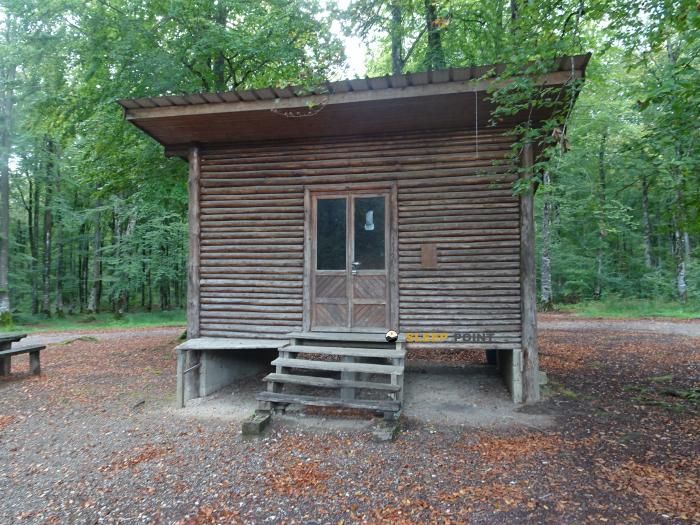

The Cabane de la hêtraie du Barbeau refuge stands at 594 meters above sea level, overlooking the surroundings of cabane de la hêtraie du barbeau, route d'ouvans, vellevans, montbéliard, doubs, borgoña-franco condado, francia metropolitana, 25430, francia. It is a key spot for mountaineers looking to spend the night or take a break. Its coordinates (47.296, 6.492) place it in a strategic position for exploring the peaks and trails of the region.
14.3°C
Feels like: 11.2°C16.3 km/h
Gusts: 32.8 km/h3670 m
Snow lineUV 0
Clouds: 76% 9.3 mm
 23 km/h
 UV máx: 5.2
 05:39
05:39
 21:24
0.9 mm
18.8 km/h
UV máx: 6.8
05:39
21:25
0 mm
15.6 km/h
UV máx: 7.1
05:39
21:26
0 mm
12.7 km/h
UV máx: 6.25
05:38
21:27
1.8 mm
11.6 km/h
UV máx: 6.9
05:38
21:27
19.2 mm
17.7 km/h
UV máx: 5.8
05:37
21:28
0 mm
14.3 km/h
UV máx: 7
05:37
21:29
21:24
0.9 mm
18.8 km/h
UV máx: 6.8
05:39
21:25
0 mm
15.6 km/h
UV máx: 7.1
05:39
21:26
0 mm
12.7 km/h
UV máx: 6.25
05:38
21:27
1.8 mm
11.6 km/h
UV máx: 6.9
05:38
21:27
19.2 mm
17.7 km/h
UV máx: 5.8
05:37
21:28
0 mm
14.3 km/h
UV máx: 7
05:37
21:29
In the environment of Vellevans , within the department of Doubs and the Burgundy - Franco Condado , Cabane de la hêtraie du Barbeau It fits better as a walking shelter or support for hiking days than as an isolated high mountain destination. Its altitude, 594 meters, places it in a relief more linked to forests, roads and hills of the Jurasian massif than to alpine terrain, so the orientation of the route and the continuity of the itinerary weigh more than the technical difficulty of high levels.
From a practical reading, this shelter can be useful for those who travel itineraries of the area like the Tour du Pays de Montbéliard or links to sectors such as Val de Cusance , Le Mont de Guillon or Les Narines du Diable . More than a base of ascension, it functions as an intermediate point within a territory of variable journeys and excursions, where it is necessary to plan the day well according to the chosen access. The close one Mont de Vey less than 3 km away, it helps to understand the character of the landscape: modesty looms and elevations, with a more panoramic and touring interest than in a strict sense.
The main precaution here is logistics. There is no immediate source next to the shelter and the nearest one is more than 3 km away, so it is necessary to get out with sufficient water and not to have supply at the last moment. It is also reasonable to provide for basic autonomy and to review the itinerary before the departure, especially if several local trails are linked or through sections of forest where the main reference will be the route of the road. In this context, the Cabane de la hêtraie du Barbeau makes sense for field-based, flexible stages and simple support within a network of Doubs routes.


📏 6.2 Km
⛰️ 722 m

📏 6.4 Km
⛰️ 760 m

📏 7.1 Km
⛰️ 743 m

📏 8.7 Km
⛰️ 632 m

📏 9.7 Km
⛰️ 658 m

📏 10.4 Km
⛰️ 645 m

📏 12.4 Km
⛰️ 620 m

📏 15.4 Km
⛰️ 950 m
Download the app and start looking for the shelter of your next adventure


Find a place to sleep before night falls.


