Mountain refuge Cabane de Balavaux
We have it listed in the app!
We have it listed in the app!
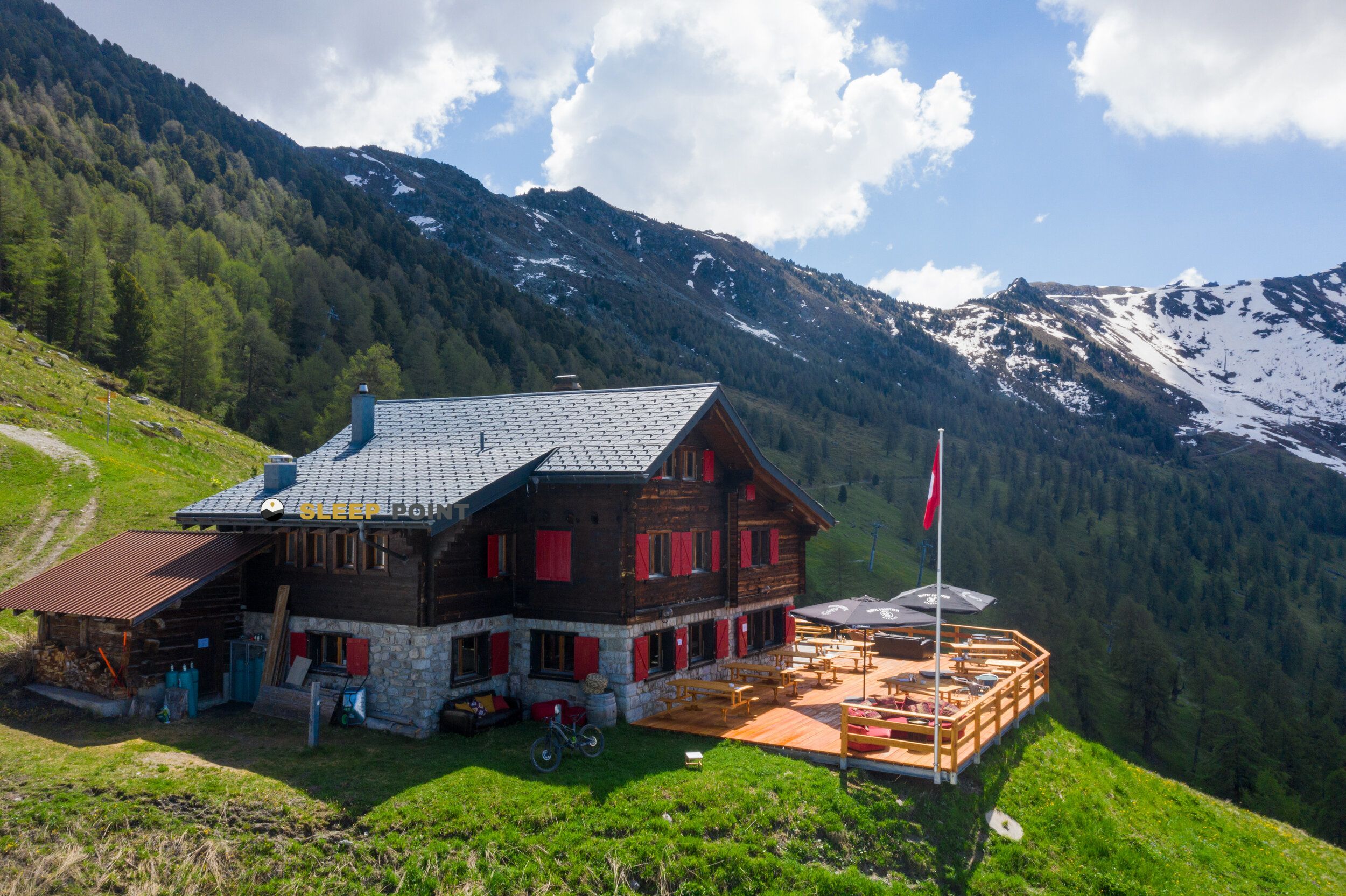

Located at 2042 m above sea level, the Cabane de Balavaux refuge is a true haven of peace in cabane de balavaux, route de balavaux, isérables, martigny, vallés, 1997, suiza. Connect with nature and use its coordinates (46.155, 7.278) to guide your steps to its door.
8.6°C
Feels like: 6.8°C1.8 km/h
Gusts: 27 km/h3590 m
Snow lineUV 1.95
Clouds: 95% 11.3 mm
 12.5 km/h
 UV máx: 5.75
 05:41
05:41
 21:16
0.9 mm
10 km/h
UV máx: 4.7
05:40
21:17
0 mm
12.9 km/h
UV máx: 7.45
05:40
21:18
0 mm
10.8 km/h
UV máx: 7.4
05:40
21:19
0 mm
12.7 km/h
UV máx: 6.75
05:39
21:19
6.3 mm
11.5 km/h
UV máx: 3.4
05:39
21:20
0 mm
9.8 km/h
UV máx: 7.5
05:39
21:21
21:16
0.9 mm
10 km/h
UV máx: 4.7
05:40
21:17
0 mm
12.9 km/h
UV máx: 7.45
05:40
21:18
0 mm
10.8 km/h
UV máx: 7.4
05:40
21:19
0 mm
12.7 km/h
UV máx: 6.75
05:39
21:19
6.3 mm
11.5 km/h
UV máx: 3.4
05:39
21:20
0 mm
9.8 km/h
UV máx: 7.5
05:39
21:21
At 2042 meters, the Cabane de Balavaux fits better as an intermediate stop than as a destination in itself. Its position, in the surroundings of Isérables and within the Valais, places it in a useful strip to read the terrain between sides, cords and links of the area of Bagnes and Nendaz. The map appears near variable continuity routes, such as the Tour du Val de Bagnes , the route to Col de la Chaux - Cabane Mont-Fort or the journey of Trail Verbier St-Bernard , which reinforces its support role in long days.
More than a shelter associated with a single ascension, it works as a reference to be oriented in a sector where local pedestrian roads and more far-reaching routes converge. The proximity of reliefs like the Dent de Nendaz , already very close to the shelter, and summits such as Le Fou or Dents Rousses helps to understand the mountainous character of the environment: open terrain, hillside changes and steps that make it necessary to look at the planned itinerary. In this context, it is logical to raise it as a point of passage within a journey or as a support to divide a day.
A conservative reading should be adopted. If the output depends on finding water or having specific services, it is better not to take anything for granted. There are relatively close recorded sources, with one to about 1.7 km and one to just under 2 km, but that distance already requires to provide for the supply with margin and not to rely all the logistics at the last moment.
It is also interesting to keep in mind the relative isolation of the place. Although the network of trails in the sector is wide, the exact distances of the nearby routes are variable and the shelter should not be understood as an urban point of support, but as a mountain reference. For those who cross this part of the Valais, the main utility is in their position on the ground and in their ability to fit within a well-planned day.


Download the app and start looking for the shelter of your next adventure


Find a place to sleep before night falls.


