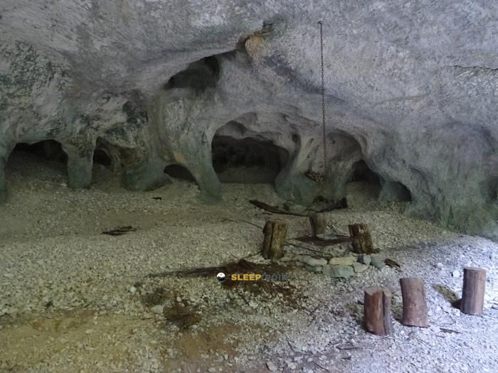
Mountain refuge Abri des Baumes
We have it listed in the app!
We have it listed in the app!


The mountains of cabane sous auge de barésia sur ain, chemin de sous le bois, les cyclamens, coyron, saint-claude, jura, borgoña-franco condado, francia metropolitana, 39260, francia hide essential places like the Abri des Baumes refuge. Situated at an elevation of 450 meters, it offers protection and rest. Its exact coordinates are 46.531, 5.686.
16.9°C
Feels like: 16°C9 km/h
Gusts: 19.1 km/h3040 m
Snow lineUV 2.1
Clouds: 100% 20.8 mm
 14.7 km/h
 UV máx: 3.3
 05:46
05:46
 21:24
0 mm
9.4 km/h
UV máx: 6.45
05:45
21:25
0 mm
15.2 km/h
UV máx: 7.2
05:45
21:26
0 mm
7 km/h
UV máx: 6.55
05:45
21:27
0.3 mm
14.8 km/h
UV máx: 6.6
05:44
21:28
5.7 mm
12.6 km/h
UV máx: 3.6
05:44
21:28
0 mm
14.8 km/h
UV máx: 7.05
05:44
21:29
21:24
0 mm
9.4 km/h
UV máx: 6.45
05:45
21:25
0 mm
15.2 km/h
UV máx: 7.2
05:45
21:26
0 mm
7 km/h
UV máx: 6.55
05:45
21:27
0.3 mm
14.8 km/h
UV máx: 6.6
05:44
21:28
5.7 mm
12.6 km/h
UV máx: 3.6
05:44
21:28
0 mm
14.8 km/h
UV máx: 7.05
05:44
21:29
Located at a height of 450 meters, the surroundings of the Abri des Baumes is defined by a relief of half mountain conditioned by the proximity of the water and the forest density of the department of Swear . At this altitude, the ground usually has a constant humidity, typical of the region of Burgundy - Franco Condado where the riverside vegetation and the calcareous outings mark the pattern of the road. It is not a high mountain environment, but landscape configuration requires attention to orientation in the paths that cross the term of Coyron .
The climate in this area of France is characterized by rapid transitions, making this type of construction a necessary reference point during unstable meteor days. The Abri des Baumes acts as a tactical guard within a network of roads that connect localities such as La Tour-du-Meix and Largillay- Marsonnay . Its location allows to break the effort in sectors where the gap, although moderate, is sustained by the sinuosity of the route.
For those who travel a shelter + long journey the enclave becomes important by integrating into the itinerary of the Tour du Lac de Vouglans . With more than 80 km of total route, this route requires logistical support where the senderist can reorganize his equipment or protect himself from precipitation. Other trails like The Thoreigne Plaine they pass through the vicinity, strengthening their role as a knot of pedestrian communications in the southern sector of the lake.
With regard to autonomy, it is essential to provide for water supply before reaching the area. The nearest source is located approximately 1.8 km, which requires early management of the reserves if you plan to stay or make a long stop. In the absence of saved services, self-reliance is the norm. Local mapping should always be verified to identify the steps towards Chemin de sous le bois and ensure progression to the nearest inhabited cores.


📏 10.3 Km
⛰️ 438 m
📏 11.3 Km
⛰️ 558 m

📏 11.9 Km
⛰️ 866 m

📏 12.1 Km
⛰️ 604 m

📏 12.5 Km
⛰️ 769 m

📏 13.1 Km
⛰️ 910 m

📏 14.6 Km
⛰️ 996 m

📏 15.2 Km
⛰️ 976 m
Download the app and start looking for the shelter of your next adventure


Find a place to sleep before night falls.


