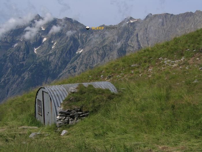
Mountain refuge Abri de la Vivolle
We have it listed in the app!
We have it listed in the app!


Strategically located in chemin d'Été, le périer, chantepérier, grenoble, isère, auvergne-rhône-alpes, francia metropolitana, 38740, francia, the Abri de la Vivolle refuge makes exploring the area easier. At 2405 meters above sea level, this point of interest (44.971, 6.008) is a vital resource when planning your route.
6.6°C
Feels like: 3.7°C1.1 km/h
Gusts: 19.1 km/h3960 m
Snow lineUV 0
Clouds: 100% 34.6 mm
 16.9 km/h
 UV máx: 5.1
 05:51
05:51
 21:17
0 mm
13.1 km/h
UV máx: 8.05
05:50
21:18
0 mm
9.1 km/h
UV máx: 8.15
05:50
21:18
0 mm
6.8 km/h
UV máx: 8.1
05:50
21:19
1.2 mm
12.6 km/h
UV máx: 7.25
05:49
21:20
0 mm
12.4 km/h
UV máx: 5.15
05:49
21:20
0 mm
11.1 km/h
UV máx: 7.9
05:49
21:21
21:17
0 mm
13.1 km/h
UV máx: 8.05
05:50
21:18
0 mm
9.1 km/h
UV máx: 8.15
05:50
21:18
0 mm
6.8 km/h
UV máx: 8.1
05:50
21:19
1.2 mm
12.6 km/h
UV máx: 7.25
05:49
21:20
0 mm
12.4 km/h
UV máx: 5.15
05:49
21:20
0 mm
11.1 km/h
UV máx: 7.9
05:49
21:21
Access to high mountain areas in the Chancerier requires rigorous planning, with a particular focus on personal autonomy and constant monitoring of weather forecasting. This enclave is located in an area of relief marked within the department of Isère , acting as an essential point of support for those who move through the most demanding aspects of the region of Auvergne- Rhône- Alpes . The direct exposure to the elements to these levels requires that the Abri de la Vivolle as a security resource or austere logistics base. Its location facilitates the movement between deep valleys and technical cords, becoming naturally integrated into the network of itineraries of the Réseau pédestre de l'Oisans .
The proximity to summits of relevance makes this point a center of tactical operations for mountaineers who seek to coronate peaks like the Sommet des Clottous or Pointe de Malhaubert . For higher technical or physical ascension, such as access to Le Rochail or the imposing Le Grand Armet , the shelter allows to fail the accumulated gap from the ancient communes of Chantelouve or Le Périer . The progression on this ground, which is at 2405 meters of altitude, requires experience in reading the relief, as the routes to the Pic du Col d'Ornon or Grand Renaud They pass through steep slopes and unstable peders.
With regard to the logistics of the activity, it is possible to find a water source at a short distance, which facilitates the management of the hydration during the day without the need to carry overweight from the beginning. The shelter also performs a strategic liaison function for those who travel sections of the GR 54 or the length GR 50 , allowing to divide stages that, because of their hardness, would require extreme effort. As it is a high mountain structure, self-sufficiency in equipment and supplies is required to ensure safety in this peripheral sector. National Park of the Ecrins .


📏 0.2 Km
⛰️ 2411 m

📏 1.4 Km
⛰️ 2000 m

📏 1.4 Km
⛰️ 2350 m

📏 2 Km
⛰️ 2000 m

📏 2.2 Km
⛰️ 1560 m

📏 2.5 Km
⛰️ 1998 m
📏 2.6 Km
⛰️ 2081 m

📏 2.7 Km
⛰️ 1595 m
Download the app and start looking for the shelter of your next adventure


Find a place to sleep before night falls.


